 by
by Chicago, IL — As colder winds begin sweeping across the Midwest, the nation heads deeper into autumn with a mix of crisp air, early snowfalls, and sudden temperature swings — all under the influence of an ongoing La Niña pattern.
According to the National Oceanic and Atmospheric Administration’s (NOAA) Climate Prediction Center, November will bring above-average warmth in parts of the West, more cold-air outbreaks across the North and Northeast, and a continued lack of rainfall in drought-hit regions of the South.
November’s Dual Personality: From Snowflakes to Storms
November serves as a true transition month, bridging the warmth of fall and the onset of winter. Snow will begin spreading from high elevations in the Rockies, Sierra Nevada, and Appalachians into lower elevations and northern cities like Boston, Chicago, and Detroit by mid-to-late November.
At the same time, the South and Southeast will enter their “second severe weather season,” as warm Gulf air collides with cold Arctic fronts. This unstable setup could trigger tornadoes and severe thunderstorms, especially across Texas, Oklahoma, and the lower Mississippi Valley.
Last year, a two-day tornado outbreak swept through Oklahoma and Missouri, spawning more than a dozen twisters and marking an intense end to the fall season.
Temperature Outlook: Mild West, Colder North
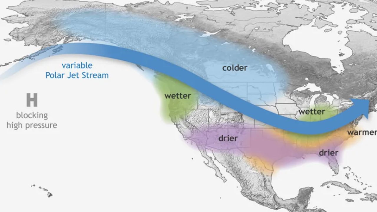
Forecasters expect the La Niña effect to bring warmer-than-average temperatures to much of the West Coast and Central Plains, fueled by a ridge of high pressure that’s likely to persist through the month.
However, the Northeast and Upper Midwest — including areas like Chicago, Detroit, and Buffalo — will likely experience frequent cold snaps as Canadian air masses drift southward later in November.
Overall, the national temperature average is projected to stay near normal, though sharp fluctuations between warm and cold spells will keep weather conditions unpredictable.
Read Also: Tallahassee Weather Forecast: Breezy, Cool Start to the Week Before Warmer Midweek Temperatures
Precipitation Outlook: Wet North, Dry South
The precipitation forecast fits a classic La Niña pattern, with wetter conditions in the North and drier weather across the South.
- Drier-than-average weather is likely to persist in the Southeast and Mid-Atlantic, deepening drought conditions in places like Alabama, Georgia, and the Carolinas.
- In Tuscaloosa, Alabama, only 2.26 inches of rain have fallen this fall — the 10th driest on record so far.
- Above-normal rainfall and mountain snow are expected across the Pacific Northwest and Northern Rockies, which could help water reserves but also increase the potential for localized flooding.
This north-south weather split — wet in the North, dry in the South — is a well-known hallmark of La Niña winters.
Shorter Days, Earlier Nights
November also signals the end of daylight saving time and the start of longer nights.
On Nov. 2 at 2 a.m., most Americans will set their clocks back one hour, except for those in Arizona and Hawaii, where clocks remain unchanged year-round.
With the approach of the winter solstice, daylight continues to dwindle — northern states will lose more than an hour of sunlight by month’s end, bringing earlier sunsets and cooler evenings.
Final Outlook
From early snowfalls in the North to stormy conditions in the South and mild afternoons out West, November is shaping up to be a month of sharp contrasts — a perfect preview of what the coming La Niña winter has in store.
What kind of weather are you experiencing in your area this week? Share your thoughts and photos at race-day-live.com.