


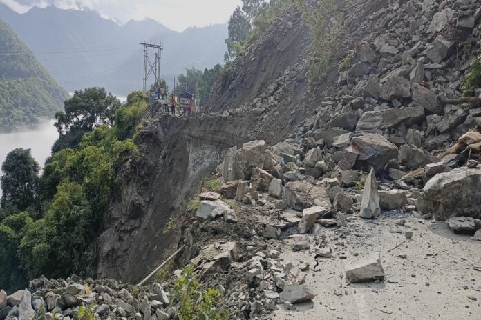
In many parts of the world, landslides often go unnoticed, but they can lead to significant disasters, altering landscapes and claiming lives. The tragic landslide in Oso, Washington, a decade ago, serves as a stark reminder of their destructive potential. Here’s what you need to know about landslides:
What Are Landslides?
Landslides occur when masses of earth and rock move downhill. They can happen independently or as a result of earthquakes, volcanic eruptions, heavy rainfall, or human activities like logging. Landslides come in various forms, including shallow slides, deep-seated movements, debris flows, creeps, and rock falls.
Understanding the Risks
Climate change exacerbates the risk of landslides by intensifying storms and wildfires, which destabilize soil. Areas prone to landslides include regions with steep slopes, recent wildfires, or heavy rainfall. Melting permafrost, retreating glaciers, and seismic activity also contribute to landslide susceptibility.
Studying Landslides
Scientists use advanced techniques like lidar mapping to study landslide-prone areas and identify potential risks. Lidar mapping provides detailed surface images, allowing researchers to analyze terrain features and historical landslide occurrences. Field observations complement these findings, helping experts understand ground conditions and assess landslide hazards.

Assessing Personal Risk
Individuals can assess their risk of landslides by checking national landslide inventories and consulting with local authorities. Steep slopes, recent wildfires, and saturated ground increase vulnerability to landslides. While certain areas may have warning systems for landslide hazards, predicting landslides outside of burned zones remains challenging.
Related Articles:
- New York Rep Hakeem Jeffries, 53, Points Finger at Republicans’ ‘Performative Politics’
- Polarizing Politics: Texas in the Spotlight
- Trio Arrested in $300k Retail Theft Ring Bust
Warning Systems and Preparedness
The National Weather Service issues alerts for debris flows in wildfire-affected areas based on USGS data. Efforts to expand partnerships and improve preparedness aim to enhance landslide warning systems. Some regions, like North Carolina and Sitka, Alaska, have developed maps and online dashboards to inform residents about landslide risks during heavy rainfall.
By understanding the causes and signs of landslides and staying informed about local risks, individuals and communities can take proactive measures to mitigate the impact of these natural hazards.


+ There are no comments
Add yours